Showing posts with label Land Records. Show all posts

Monday, December 7, 2020

Jacob Hamman’s Land Deed

One of my goals for my Genealogy Road Trip 2020 was to find and stand on my maternal great-great grandfather’s land in Fredonia Township, Plymouth County, Iowa. While traditional searching (see previous posts Finding Jacob Hamman’s Land-First Understanding Iowa Land and Searching for the Will and the Land of Jacob Hamman) on Ancestry, FamilySearch, Bureau of Land Management, etc. yielded no results going to the Plymouth County Courthouse in Le Mars, Iowa this summer allowed me to accomplish my goals of finding and standing on Jacob’s land.

While I knew now  where Jacob’s land was, I wanted to be able to get a copy of his actual land deed. Would this deed give me more information about Jacob and the land? I knew the actual deed would be in Book 5 page 280 of Land Deeds. I have been disappointed before to find the ledger I am looking for to have disappeared or the print in the ledger to be difficult to read. I don’t get too excited until I have a copy of the actual deed in my possession. What would happen his time?

Copy of Plymouth County, Iowa Land Deeds Book 5 page 280:


(click on images to enlarge)

Transcription:

This indenture made this Twenty second day of October in the year of our Lord one thousand eight hundred and ninety five between The Western Land Company a corporation created and organized under and by virtue of the laws of the State of Iowa party of the first part and Jakob Hamman of Plymouth County State of Iowa party of the second part, Witnesseth, That the party of the first part in consideration of the sum of Six Thousand four hundred ($6,400) Dollars paid by the said party of the second part, the receipt whereof is hereby acknowledged does thereby grant, bargain, sell and convey unto the said party of the second part his heirs and assigns forever all that tract or parcel of land lying and being in the County of Plymouth and State of Iowa described as following to wit:

The West half (W ½) of Section No. of the second part this Eleven (11) in Township No. Ninety three (93) North of Range No. Forty four (44) West of the Fifth Principal Meridian containing according to the United States Survey three hundred twenty (320) acres be the same more or less being the same premises contracted to be sold to Jakob Hamman by The Western Land Company by contract executed the 20th day of September 1886 in pursuance and fulfillment of which said contract this conveyance is made and executed.

To have and to hold the same, Together with all the hereditaments and appurtenances thereunto belonging, or in anywise appertaining to the said party of the second part his heirs and assigns forever, and the said The Western Land Company, party of the first part, does covenant with the party of the second part his heirs and assigns that it is well seized in fee of the lands and premises aforesaid, and has good right to all and convey the same in manner and form aforesaid that the same are free from all incumbrances; created, and the above _? and granted lands in the quiet and peaceable possession of the said party of the second part his heirs and assigns, against all persons lawfully claiming or to claim the whole or any part thereof, the said party of the first part will warrant and defend. Excepting however from the operation of the foregoing covenants all taxes and assessments levied or imposed upon said premises or any part thereof since the 20th day of September 1886 and also all titles, interests, liens or encumbrances, created, suffered or imposed thereon by said Jakob Hamman or his assigns.

In testimony, Whereof the said The Western Land Company, party of the first part, has by Ephraim McMurtrie Its Attorney in fact, duly appointed in writing under the seal of said Company, caused these presents to be signed and sealed the day and year first above written.

The Western Land Company (seal)

By Ephraim McMurtrie

Attorney in fact

State of Illinois

County of Cook on this 28th day of October A. D. 1895 before me, F. L. Brown a Notary Public written and for said County personally came Ephraim McMurtree personally to me known to be the identical person whose name is subscribed to the foregoing instrument as attorney in fact for the Western Land Company, the grantor therein named and acknowledged said instrument to be the act and deed of The Western Land Company grantor, by him as its attorney in fact thereunto appointed, voluntarily done and executed.

In Witness Whereof, I have hereunto subscribed my name and affixed my Notarial seal on the date last above written.

F. L. Brown

Notary Public

(seal)

Filed for Record October 31 A.D. 1895 at 8 o’clock A.M.

G.W. McLain

Recorder

Some thoughts about this find:

About 320 acres of land at a cost of $6,400 would mean that the land in 1895 cost $20/acre.

What was The Western Land Company? After doing some additional research I learned that “it was a corporation created and organized under and by virtue of the laws of the State of Iowa". In my previous post Searching for the Will and the Land of Jacob Hamman I have a copy of the ledger which shows this was the first transaction for this piece of land. Everything fits!

  • Except…after doing some research at the State level with an archivist I found out more about The Western Land Company. I learned that “Section 11, Township 93N Range 44W was part of a large grant of land by the State of Iowa to the Iowa Falls and Sioux City Railroad for railroad construction. It appears that there were at least a couple of transactions involving this property prior to the Western Land Company selling the W 1/2 of the section to Jakob Hamman in 1895. The Real Estate Transfer Books kept at the County Auditor's Office in Plymouth County should record all transactions for T93N R44W, Section 11.” Interesting.

As a blogger I like to share my blog posts on Facebook with groups from the area where I am researching. Sometimes you may find a ‘cousin’ you didn’t previously know about, a new source to search for documents or a researcher in the area may find an idea from something I have done that helps them in their research.

I posted my last blogs on the Iowa Genealogy Facebook page. Several people made suggestions or even found a record I previously was unable to find. The following is one such record. (Thank-you Alan Cable for yet another piece of this puzzle.) I have searched Bureau of Land Records for years trying to find Jacob’s land. I have used a variety of spellings and even after finding out the Township, Range and Section numbers I was still unable to find Jacob’s land. This find adds another piece to the puzzle:


Transcription of second listing on page:

All of Section 11 Township 93 Range 44 /640 acres/ Selected for the Dubuque and Pacific Rail Road and Branch under Act May 15, 1856 / Approved December 27, 1858

  • The Act of May 15, 1856 was an Act of Congress making a grant of lands to the State of Iowa, in alternate sections to aid in the construction of certain railroads in the State. The railroad was slated to be built from Dubuque, Iowa on the Mississippi River west to the Missouri River near Sioux City.
  • The Iowa Falls & Sioux City Railroad was incorporated 1 October 1867 and was a subsidiary of the Dubuque & Sioux City Railroad.

I have gained so many pieces of this puzzle about Jacob’s land.  More then just 'land purchased' and dates.  I am very grateful to everyone that helped on this journey!

Now I’d like to know what the ‘covenant’ was and if I can obtain a copy of that?  Any ideas?

If you have any corrections or additions or stories to share I look forward to hearing them.

Enjoy the journey,
Debby

Sunday, December 6, 2020

Searching for the Will and the Land of Jacob Hamman

On my recent Genealogy Road Trip 2020 I wanted to find the land that my Great-Great Grandfather Jacob owned in Plymouth County, Iowa so I could go and see it. In my previous post Finding Jacob Hamman’s Land-First Understanding Iowa Land I learned about Iowa land and that I needed the township, section and range numbers in order to see where the land was located today. Would I be able to find these mentioned in Jacob’s Will perhaps?

In several previous posts I learned a great deal about the life of my maternal Great-Great Grandfather Jacob Hamman who immigrated from Luxembourg in the mid 1800s. (See previous posts: Immigration, Naturalization and Ship Travel Presentation, My First Naturalization Papers-Jacob Hamman, and Sunday Obituary-Jacob Hamman.) I also thought I had found a Will for Jacob and talked about that in the post The San Diego Genealogical Society Presents Laurice Johnson. As I transcribed the Will I realized it was not for ‘my’ Jacob Hamman who lived in Plymouth County, Iowa. Bummer! Back to square one.

I went back to his obituary and remembered that Jacob had died suddenly from an asthma attack. Did he already have a Will or did he die intestate, not having made a will before he died?

Already having been to the Plymouth County Courthouse the day before I returned the following day to see if I could find Jacob’s Will. Traveling to sites during Covid was an adventure. Would sites be open? Would I be able to search? What might I find? Traveling with a dog in the Summer added another obstacle I was dealing with. It meant leaving Harley in my Camper. The day was not too very hot and I did find a tree right outside the Courthouse to park under. Windows open, water available and I told Harley I wouldn’t be long. LOL! How many times have you said that exact same thing to a family member or friend that was with you while you were doing research?

I was VERY fortunate to have found a clerk ready to help and there was no one else there searching for records. She helped me search and sure enough there was a Probate Record for Jacob Hamman who died…intestate as I had guessed. No Will but the record of his estate was there. Would these documents help me locate his land?

I looked through the file and decided which records I should get copies of. I handed over my rather lengthy list to the clerk and asked if she’d mind if I left the room to go check on my dog outside in my vehicle while she made copies. She surprised me by saying, “Only if you bring him up here for us to see and, oh, can we pet him?” I couldn’t believe what I was hearing! People often help us because it’s their job, sometimes very grudgingly, but never before has anyone asked me to bring my dog into a records room so I wouldn’t have to worry about him getting hot.

You never know how helpful others will be when you are looking for records. Sometimes you meet the nicest people who go out of their way to help you. A very special thank-you to all the people I met with at the Plymouth County Courthouse! What a wonderful group of people who went out of their way to help me.

What could I learn from the pages and pages of records? The numerous documents about Jacob’s Estate were in no particular order. I continued to scan documents, records of what Jacob owned from plows to livestock and what he owed at the time of his death. (More on the contents of Jacob’s Estate in a later post.) As I looked through the pages … there it was! On the last page of the Final Report In the matter of the estate of Jacob Hamman, deceased presented to the District Court of the State of Iowa, In and for Plymouth County at the October Term 1902:


…the west half of section 11, township 93, range 44 west of 5 P.M. [prime meridian] …YES!! I found it!!!

Now back to the Plymouth County Recorder’s office one floor below. Once I knew the township, section and range numbers I could find the right ledger for the names. This is what I found on page 375:

(click on photos to enlarge)

Wow! Jacob was listed as the first buyer (Grantee) of the land. He purchased the land from the Western Land Company who was working on behalf of the State of Iowa to sell the land. Jacob filed his claim on 31 October 1895. Now I can find a copy of the land deed in Book 5 on page 280 in the Auditor’s Office. Luckily, the Auditor’s Office is just across the hall on the same floor in the Plymouth County Courthouse.

The Clerk in the Auditor’s Office was also able to look at a current map of this land in Fredonia township, Plymouth County and tell me that today if I drove from the Courthouse (Le Mars, Iowa) on Route 3 out to Polk Avenue (before the town of Remsen) and then drove out to 120th Street Jacob’s land would be on the right hand side of Polk north of 120th street. OK, Harley and I are off.

As I turned off Route 3 Polk Avenue was paved for a bit. The first numbered street I came to was 160th Street. I had a way to go. I was in the middle of huge fields of corn and now the road turned to dirt. I drove and drove and drove on a bumpy dirt road past 


Deep Creek, which didn't seem too deep right now, and drove 


until ... there it was! I came to the cross street … 120th. Finally, I had arrived!

This was once Jacob's land.


WOW!! How amazing! What a feeling of success! I was able to shout (there was no one around) “Jacob, I found your land!” One hundred and twenty years after your death in 1900 your great-great-granddaughter came to see the land that you farmed and where you raised your family. You came all the way from Luxembourg to start a new life here in Iowa. I only drove from San Diego. I can’t help but wonder how the actual land and life you built here in Iowa compared to the dreams of that young man of 25 years who came across the Atlantic Ocean on the ship Atlantic in 1859 and landed first in New York City before your journey to Iowa?

Now, can I find a copy of the actual land deed and will it tell me more about Jacob and this land?

If you have any corrections or additions or stories to share I look forward to hearing them.

Enjoy the journey,
Debby


Friday, December 4, 2020

Finding Jacob Hamman’s Land - First Understanding Iowa Land

(click on images to enlarge)

Recently, I was in search of land possibly owned by my maternal great-great grandfather Jacob Hamman in Plymouth County, Iowa. (See previous posts Immigration, Naturalization and Ship Travel Presentation, Sunday Obituary-Jacob HammanMy First Naturalization Papers-Jacob Hamman)  I wanted to be able to go and stand on the land my ancestor once owned in Iowa or at least see where the land was while I was on my Genealogy Road Trip. (see previous post)

Understanding the history of the land and how the land was portioned was going to help me understand any possible land deed I found for Jacob. Doing the background research first always helps in locating and understanding local land deeds. I actually did not do this first but rather as I went along. Good time to learn from my mistakes. I would have understood so much more if I’d done this first.

First, the history of the land: what we now know as Iowa first belonged to France, then Spain, then France again. The land was then purchased by America as part of the Louisiana Purchase. In 1834 this land was part of the Michigan Territory and then in 1836 it was under the Wisconsin Territory.

The Iowa Territory wasn’t actually established until 1838. (Many places to consider when looking for records!) After Iowa became part of the United States most of the land was listed as ‘public domain land’, land that legally belongs to the citizenry. ‘Public domain land’ is managed by a public entity such as a state, region, province or municipality-directly or by institutes or state companies. This land was then surveyed and divided into townships (36 square mile sections).


Iowa was termed a Federal land state with the land being public domain land. The government granted land through cash sales, homesteads, military bounty land warrants, etc. The sale of the land was used to build schools, roads, etc.

According to America's Public Lands, the Homestead Act of 1862 was a law passed by Congress “to facilitate the settlement and development of vast areas of public domain west of the Mississippi River by citizens and masses of immigrants moving to America for a better life.” Most of the laws required some level of development effort on the land before it could be purchased.

Iowa uses the rectangular land survey system of section, township and range. The townships were six-mile square blocks of land, divided into 36 one-mile squares called sections. The township was numbered north and south, starting from the centerline, and the range was numbered east and west starting from the centerline.

The records for Plymouth County Iowa, where my ancestor lived, are located at the Plymouth County Courthouse in Le Mars, Iowa.


Once I got to the Plymouth County Recorder's Office  I learned I would need the township, range and section number for the land in order to identify where the land is located today. There wasn’t an index to look in to find Jacob’s land by searching his name. Where could I possibly find the township, range and section numbers? Back to square one. The only thing I could think of was would Jacob have mentioned the land in his Will? Luckily, I was already in the right building and only needed to go upstairs to get a copy of his Will and see if the land was mentioned.

If you have any corrections or additions or stories to share I look forward to hearing them.

Enjoy the journey,
Debby


Sunday, August 9, 2020

Gerald G. Warner, Land Owner

In my last two posts I have followed the life of my paternal great uncle Gerald Warner (The Childhood of Gerald Gilbert Warner and The Adult Life of Gerald Gilbert Warner). I know that Gerald moved from Long Island, New York to South Dakota about 1912-1913. According to the 1930 and 1940 US Federal Census records Gerald rented a home but was listed on the Farm Schedule. Hmm…what does that mean?

    When I searched FAQs about the 1930 Farm Schedules I found that most of the Farm Schedules are missing. So, no help there. I did find the following information about crops in Brule, County:


I went back to the 1930 census, to see what I had missed previously. On this one I had missed the fact that Gerald owned his home in 1930. I know that in 1920 he was in Plummer Township in Brule County and in 1930 he was in Plainfield Township also in Brule County. I wondered if I could find a land record for this purchase?

Before I started searching for a land record I needed to know about the land in the area. I am used to searching for land records back East where the system of Metes and Bounds (system of describing the land or real estate commonly used in the East based on a system used in England) is used when surveying land. What system is used in South Dakota? (I like to go to the FamilySearch Wiki to start my research.) South Dakota uses the rectangular land survey system of section, township and range. Townships were six-mile square blocks of land, divided into 36 one-mile squares called sections. The township was numbered north and south, starting from the centerline, and the range was numbered east and west starting from the centerline.

Gerald lived in Brule County. This is the map of the counties in South Dakota in 1930: 

    According to the FamilySearch Wiki on South Dakota: When South Dakota was acquired by the United States most of the land became public domain. The federal government surveyed the land into townships and transferred the land to private ownership through local land offices. The first land office was established at Vermillion, South Dakota in 1861. Land could be obtained by paying cash or by Homesteading after 1862. The records for these transactions are in the County Clerk or Recorder’s Offices.

Chamberlain, South Dakota is the County Seat for Brule County. I began looking in the Index book of Grantors and Grantees but nothing was listed for Gerald Warner as Grantee (buying land) in the land records. I had previously noted that on both his World War I and World War II Draft Registration Cards Gerald signed his name as G G Warner. Ah, there it was… G G Warner purchased land in Plainfield County in 1923. That has to be my Great Uncle Gerald! This is the land deed I was able to locate:

Transcription:  1 December 1923.  The Northeast quarter of section 19 in township one hundred three  North range sixty seven West of the 5th P.M. containing 160 acres more or less according to the US Government survey thereof, and free of encumbrance.  Revenue stamps $7.00.  

Gerald bought the land from a woman named Mamie Westendorf, a single woman from Los Angeles, for the price of one dollar and other good and valuable considerations.  I wonder what those were?  The Register of Deeds said there is rarely anything other than $1.00 listed as a price back then.  Interesting. 

OK, but where is that land today? I really wanted to go see it and stand there. To know that someone cared enough to come and see his land. Well, very special thanks to Register of Deeds, Glenda Andrea and Kris. They took time out of their busy day to help this stranger from California with a most unusual request on a late Tuesday afternoon in August. They were able to show me on a map of the County where the property was and they gave me directions: Take route 90 East, get off the Exit for Route 45 South. Go to the Golf Course and turn right on road 253 and go 2 miles to road 365 and the property will be on the left. I was surprised to see that many roads don’t have names just street numbers. I missed the golf course the first time but finally found road 253 and drove about 2 miles :


and the road ended. The property is now part of a much larger farm and there are wind turbines off in the distance. Gerald’s section seemed to be vacant but…I found it and this is what it looks like today:


No houses or barns are visible now, but, I found it and stood on Gerald’s land!

I wonder if this picture

was a picture taken to send back East to family to show his new land purchase? Maybe? I wish there had been buildings to help me determine this. I did get the name of a local historian I can contact. I also applied to get a copy of a death certificate for a Gerald G Warner in Brule, South Dakota to see if this is my great Uncle’s. That may take a while to get. I also need to get a copy of his Will. The office I needed was closed while I was there, unfortunately.  More to follow at a later date.

If you have any corrections or additions or stories to share I look forward to hearing them.
Enjoy the journey,
Debby

Sunday, September 8, 2019

How Close Did my Ancestors Live to Each Other

Have you ever wondered how close your ancestors may have lived to each other? I found a land document that answered that question for me about the Benjamin and Warner lines.

When I am back East visiting family I always want to spend some time at the Suffolk County Land Records Department in Riverhead, New York. I am constantly amazed at some of the things I am finding in a location that many choose not to explore. A while back I discovered the Archives room in the Land Records office. The ledgers here are the fist record books dating back to the early 1700s, I believe. These ledgers and are not out on public display in the regular land deed section, I am guessing, due to their age. Ledgers from this time period need to be specifically requested and if the pages are not in sleeve protectors then you must use gloves to touch and turn the pages. When I was there in May I was waiting for the Archivist, Sharon Pullen, and stopped to look at several of the display cases that were there. I am usually in such a hurry to get copies of the records I am looking for and get on with my day that I rarely take the time to look at what is on display figuring it doesn’t relate to me anyway. This time was different…

The display case had to do with Unacknowledged Deeds.

(photo unacknowledged deeds)


Unacknowledged Deeds as stated in the display case are deeds that do “not contain a notary’s acknowledgement of the signature”. That’s interesting and I had never thought to verify that there was a notary’s signature on the documents I have found. Good information to have as a genealogist. I continued to look at the documents in the case and found the following:

(click on image to enlarge)


Transcription:

Know all men by these presents that I Nathan Benjamin of the Town of Riverhead in the County of Suffolk and state of New York for and in Consideration of the sum of twelve hundred and fifty dollars to me in hand paid by John Benjamin of the town County of Suffolk and state aforesaid John Benjamin and I for my self and heirs executors and administrators do bargain and sell unto John Benj his heirs executors administrations and assigns for ever a sertain tract or parcel of land situate and lying in the town of riverhead County of Suffolk and state of New York and bounded as follows _ beginning at the North East corner of the land Called listcums place thence running westerly by the land of James Warner unto the land of Benjamin Edwards thence running easterly through the middle of the pond by that land of Benjamin Edwards until it strikes into the middle road thence Easterly by the middle road unto the highway that leads from Richard Albertsons mill to the north road thence northerly by said highway as far a the north end of James Hullses land lying the west side of the highway thence running easterly by the land of James Hulls twenty five rods thence running southerly by the land of James hulls unto the land of James Terry or middle of the pond thence easterly by the land of James terry unto the land of William Horton thence running northerly by the land of William Horton as far as a hedge fence North end of the first cleared lot Northward of the uncleared land thence westerly by the said hedge fence the north end the said cleared lot unto the North west corner thence westerly from the Corner a strait corse to the northeast Corner of theaforesaid listum place or place of beginning which closes the farm which is by Estimation one hundred and thirty acres be the same more of less To have and to hold the above written premises with all the privileges and appertainances there unto belonging on in any wise appertaining and I the said Nathan Benjamin for myself my heirs executors and administrators do warrant and defend the above written premaces to be clean and free from all lawful claim or Claims whatever from all person or persons whomsoever Unto the said John Benjamin his heirs executors administrators and assigns forever in witness whereof I have here unto set my hand and seal this first day of April in the year of our lord one thousand eight hundred and seventeen Signed Sealed and delivered in presents of
Nathan Benjamin                                                                                 Nathan Benjamin
Daniel Benjamin


Some background on my paternal ancestors and some interesting connections that I was able to draw: 


  • There were at least 3-4 generations of men named ‘Nathan’ Benjamin.
  • Nathan Benjamin I married Deborah Clark, my 6th great-grandparents.
  • Nathan Benjamin II (1733-1805) married Jemima Aldrich, my 5th great grandparents.
  • Nathan Benjamin III (1760-1838) married Joanna Swezey, my 4th great-grandparents and parents of Jemima Benjamin who is my 3rd great-grandmother.
  • The ‘Nathan Benjamin’ must be referring to my 4th great-grandfather Nathan Benjamin III who is the only one that was living at the time this document was written.
  • Were the Nathan and Daniel Benjamin that signed as witnesses the sons of Nathan Benjamin III? I believe so.
  • James Warner (1762-1803) is my 4th great grandfather. In 1817 James had passed away but his wife Anna/Glorianna Edwards was still living.
  • James and Ana’s son Daniel Warner (my 3rd great-grandfather) had been married about 5 years at the time this document was written to Jemima Benjamin. (They married about 1812). 
  • Daniel had a brother named James Warner, Jr. (1786-1853) who married Huldah Wells in 1817. This must be the James Warner owner of the property referenced in the above document.
  • I have yet to find any documents showing James Warner Sr’s original purchase of land in the Baiting Hollow area, so, I do not know the exact location of his land. Land deeds such as this one confirm the general area the family lived and the fact that land was owned. Perhaps some of the land referenced was land James Jr. received or purchased from his father James Warner Sr?

This would mean that my 3rd great aunt and uncle, James Jr and Huldah Warner and my 4th great-grandparents Nathan & Joanna Benjamin owned adjoining property in 1817.

The ‘Terry’ and ‘Edwards’ names are also ancestral Surnames from this area. I’ll need to do additional research to see if Benjamin Edwards and James Terry who are property owners referenced are also ‘family’.

It’s amazing how one document can locate several ancestral lines in the same location at a particular point in time. One of the many reasons I enjoying looking for property deeds, acknowledged or unacknowledged. Remember to also take the time to look at display cases that are right in front of you. You’ll never know what treasures you might find and the translation was already done for me!

If you have any corrections, additions or stories to share I look forward to hearing them.
Enjoy the journey,
Debby


Sunday, June 30, 2019

A 1720 Family Land Deed for Nathaniel Warner and James Reeve

Land deeds are fascinating documents.  Sometimes land records are full of great family information and other times they can verify your ancestor was in a particular location at a particular time period.  As I was investigating early land records for Long Island, New York I started wondering about the earliest land records.  When were land records first recorded?  Who was the first to say they ‘owned’ the land?  How far back can I document my ancestor’s ownership of land?


While researching in Suffolk County, New York I learned that the King of England claimed the land as the country in this area was being settled.  Land ‘patents’ were frequently given to a small group of men as they began settling an area.  As the population grew the land was then ‘sold’ off to others.  According to the Suffolk County Clerk’s Online Records website there are land record transactions since 1857.  While searching at the County Land Records Division of the Suffolk County Center in Riverhead, New York I also discovered the Archivist room.  In a vault in the back of the room are the oldest ledgers.  When looking in the ledgers gloves are needed to turn the pages do to their age.  Several of the ledgers have been protected with archival sleeves which makes it easier to search but harder to take photos of the documents.

I recently discovered a land record attributed to my 6th and 7th great-grandfathers Nathaniel Warner and James Reeve. 


Nathaniel was the first Warner on this line to come to Long Island and remain for the rest of his life.  


(click on image to enlarge)

Transcription:                                                              from Liber B page 187
                                                                                       1739
To all Christian people to whom these presents shall come Benjamin Youngs and Samuel Hutchinson of the Town of Southold in the County of Suffolk in the Colony of New York Send Greeting whereas James Reeve, Joshua Tuthill, Mathias Huchinson, Richard Terry, Charles Booth, Thomas Goldsmith, Caleb Horton, David Horton, Daniel Tuthill, Joshua Wells, Samuel Conklin, Thomas Reeves, Nathaniel Warner, Joshua Youngs, David Stackhole, Joseph Wickham, Joshua Wells Junior, Joseph Hale?, Jonathan Dimon ?, Samuel Conkling, John Conkling and Henry Conkling all of the Town of Southold aforesaid Did and have agreed to Joyn with us the Said Benjamin Youngs and Samuel Hutchingson for to purchase of Cor. Henry Smith all the Tract of Land within mentioned and who did agree that the Same Tract of Land should be amounted Sixty Rights or Shares and that each parson abovementioned Shall have his proportion of the Said Tract of Land as follow that which is awarding to Each of their _ to Viz. James Reeve three Rights or Shares, Joshua Tuthill one Right, Mathias Hutchinson for Six Rights, Richard Terry one right, Charles Booth three rights, Thomas GoldSmith three rights, Caleb Horton three Rights, David Horton three Rights, Daniel Tuthill three Rights, Joshua Wells one Right and half, Samuel Conkling three Rights, Thomas Reeve Two Rights, Nathaniel Warner three Rights, Josiah Young Three Rights, David Pershale? three Rights, Joseph Wickham five Rights, Joshua Wells Jun. one Right and half, Joshua Wells Jun. one Right and half, Joseph Hale? One Right, Jonathan Diman one Right, Samuel Cafe One Right, John Conkling one Right and half, Henry Conkling One Right and half, We the Said Benjamin Youngs and Samuel Hutchinson the saving to Our Three Rights a piece which make up the Sixty Rights as above paid/Now Know Yee that we the Said Benjamin Youngs and Samuel Hutchinson have granted and assigned and Set over and by these present Do grant assign and Set over Unto the Several Person abovementioned and to their Heirs and assigns forever all our Right title and Interest to the Several Rights and Shares of Land which this Said persons are to have as is above Except the Joyned with us to purchase the Same always Refering our Own three rights a piece as abovesaid in Witness wereof we have hereunto set our hands and sealed this Twenty first day of February in the Year of Our Lord Christ One thousand Seven Hundred and Twenty or Twenty One.
                                                                                                                                               Benj. Youngs Seal
                                                                                                                                                       Sam. Huchinson Seal
Signed Sealed and Delivered
In the presence of
Josiah Davison, Jo_el Parshale
Recorded May the 29th 1735
? Wm Smith ?

I do not know how big the area was that James and Nathaniel obtained since the document refers to a ‘Right’ or Share.  I also do not know exactly where the land was located in the ‘Town of Southold’.  Southold was a very large area that encompasses what today is also the Town of Riverhead.  My guess, since I have looked at land ownership on a map in the Village of Southold with no mention of Nathaniel, that it was probably located around the Mattituck area.  I know that Nathaniel was frequently noted as being involved in this area.

This was an extremely difficult document to transcribe due to it’s age, about 280 years.  I took several pictures at different angles to try and minimize light reflections on the document due to the plastic sleeve the document is in.  After first transcribing the document from my photo I ran it through a program Vivid-Pix which helped me read several of the words I could not previously decipher.  I would definitely recommend this program if you are working with old documents and photos.  Vivid-Pix even has a free trail if you want to try it out before buying.


(click on image to enlarge)

I believe that the year ‘1739’ is at the top of this document.  My guess is that while the transaction is reported to have occurred in 1720 it was not actually recorded in this Ledger until 1739 probably copied from the actually document possessed by one of the holders of the deed perhaps.  The older handwriting, spellings of the times and age of the document made several of the words and names difficult to decipher.  I welcome other interpretations of the missing or incorrectly noted information.  Perhaps you can read it better or know of the missing names of several of the men?  Be sure to let me know.  I also find it interesting to see how several common in the area Surnames have changed spellings over the years.  This is definitely a document that others need to review so we can obtain all the names for historical reasons.

If you have any corrections, additions or stories to share I look forward to hearing them.
Enjoy the journey,
Debby


Sunday, March 3, 2019

1690 Long Island Land Deed

Having both maternal and paternal ancestral lines that trace back to the early 1600s I have become more and more interested in land deeds over the years.  Recently, while on Long Island and searching for land records I wondered about how and when land deeds began on Long Island? I was amazed to find a land deed from 1690 between an early settler on Long Island and Native Americans.  How surprising to find a land deed going back that far!  This is a transcription of the original that is held by the Suffolk County Historical Society in Riverhead, New York. 

 (click on image to enlarge)


Transcription:
December the 30. 1690
Be it Known unto all men whom it may concern, that we whose hands are under written, do conform unto Richard Woodhull Junior of Brookhaven, his heirs executors administrators assigns for ever to have and to hold for ever, (that is to say) the High Ways on each side of the Neck, commonly called by the English Rattle Snake Neck the high ways to be Eight-Rods wide [44 yards], down to the Meadows with fencing stuts, building timber houses yards, or any live Timber what _ _ so ever the said Richard Woodhull shall have occasion for, with all other privileges or commanages [land owned by more than one person] yards Cow houses or other buildings with a further conformation of all the Meadows that is moveable whether high or low _ ground, fresh or salt grass, both in Snake Neck and in Wonacrosscome Neck and Connecticut Meadows Lands We whose hands are under written do conform unto the said Richard Woodhull his heirs and assigns forever, And further of the said Zobacheus Sachem, with the rest whose hands are underwritten, do give and conform unto the said Richard and his heirs and assigns for ever, that is to say Yards houses barns hovels _ and fencing across our Lands, For the conveniency of his Meadows and former Deed given both in Land and Meadow, both in the old Pathway _ and new, we the Said Indians do give grant make over and Conform all ye above said promises conformations gifts or grants above mentioned And we the said Indians whose hands are underwritten freely give _ Our good friend Richard Woodhull eight Rods deep of Woodland round the Neck next to Meadows both in Snake Neck and Wonacrosscome Neck for his conveniency for Wintering of Cattle: And this we whose hands are under written do Warranty against all persons or person what so ever shall lay any claim or challenge to ye same, and we do promise and witness we our heirs and assigns for ever to maintain, and give a further _ confirmation if need require.
As witness our hands
Tabacckas Eis mark
Wasqnasatsook Eis mark
Taceques Eis mark
Pamuta Eis mark
Antuok Eis mark
Wap Eis mark
Aiof Eis mark
Posuum Eis Mark
Wud Ramps
Singed and Sealed in presence of us
Tom T Frances Eis mark
Ludas Eis mark
Richard R. Floyd Eis mark
Susabbah Lloido

Deciphered and written from the original by Mr. John Thorne (?)
At Mastic, L.I. about 1910
  • Note: Please excuse misspellings of names, etc. above.  If you know the correct spelling please let me know so corrections can be made.  There are also symbols that I was unable to replicate. 

As I transcribed this I wondered where exactly ‘Rattle Snake Neck’ was?  I searched for ‘Rattle Snake Neck, Long Island 1690’ and found the following in a book (click on title to read book for free on Google Books) entitled The Indian Place-Names on Long Island and Islands Adjacent: With Their Probable Significations by William Wallace Tooker (published in 1911)  on page 60:


Sometimes finding such a record, even though it doesn’t directly relate to your ancestors can be an amazing find.  Records like this help tell the story of the early settlers and what was happening around your ancestors.  What a treasure this document is for the history of the area!

If you have any corrections, additions or stories to share I look forward to hearing them.
Enjoy the journey,
Debby


Sunday, June 17, 2018

A Land Record With a Twist-Daniel and Jemima Benjamin Warner

My paternal grandfather’s family lived on Long Island since the late 1600s and within about a 20-30 mile area on Eastern Long Island in New York State.  Generations living in the same area has made it a lot easier for me to research a variety of records on many family members.  When I visit the area I schedule my limited time in several repositories of records where I search frantically for a variety of names on at least 8 family lines.  I frequently find documents that look promising, grab my copies and don’t usually get time to thoroughly look at them until months later.  This is the case with one such land sale document that I was able to find and get a copy of.  I enjoy looking at the records of land acquisitions and sales.  It shows what my ancestors were doing, where they lived and who their neighbors were.  I always get a chuckle, as in this document, about the references to boundaries being a tree, a hedge or a row of stones, etc.  I located this document from 1847 at the Suffolk County Historical Society in  Riverhead, New York.  It is part of a collection entitled the Ackerly Collection which consists of deeds, etc. that Mr. Ackerly transcribed that were held by family members and had not been recorded at county or town offices.

The population of Riverhead was reported as 2,373 in 1845.  In 1847 and today Baiting Hollow is part of Riverhead Town and about 5-6 miles away from Main Street. According to Seeking the Past, Writings from 1832-1905 Relating to the History of the Town of Riverhead edited by Tom Twomey with a chapter about Riverhead written by R. M. Bayles in 1882 the main occupations for Baiting Hollow were farming and furnishing firewood.  Abundant crops of grain, hay and potatoes were grown in the area.  The Supervisor of Riverhead was Sylvester Miller and Justice of the Peace was Nathan Corwin. 

Daniel and Jemima Benjamin Warner are my paternal 3x great grandparents.  They were born, raised 6 children, died and are buried in Baiting Hollow, New York.  (I believe Daniel’s father James Warner was the first Warner to live in Baiting Hollow.)

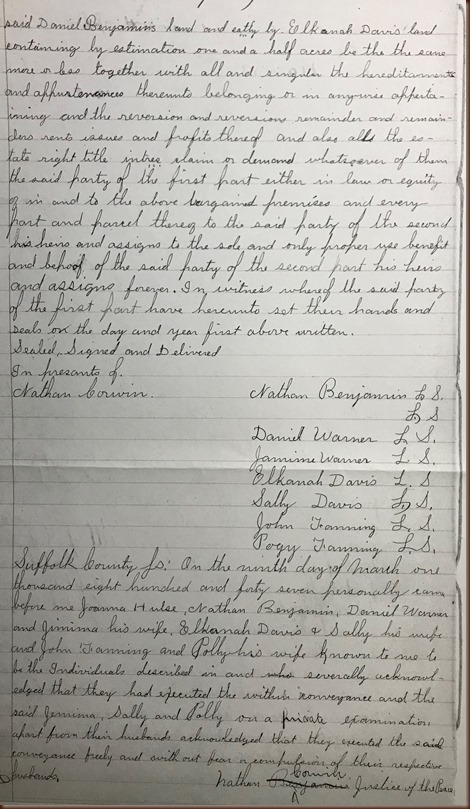
So, I located the following document that my 3x great grandparents were mentioned in.  There is also a Nathan Benjamin who I believe was related to Jemima.  I thought at first it may have been her father Nathan Benjamin (several generations were named Nathan Benjamin) but he had died in 1838.  As I reread and transcribed the document I thought, OK, it’s another piece of evidence about the lives of my ancestors but pretty ‘typical’… that is… until I read the last line.  I thought that was very different and very interesting!


Warner Daniel 1847 land transfer
Warner Daniel 1847 land transfer 2
click on image to enlarge

Transcription:  (I added in [ ] a definition to aide in understanding terminology)

This Indenture
made the third day of February in the year of our Lord one thousand eight hundred and forty seven. Between Joanna Hulse, Nathan Benjamin, Daniel Warner and Jamima his wife, Elkanah David and Sally his wife of the town of Riverhead and John Fanning and Polly his wife of the town of Southampton County of Suffolk and State of New York of the first part and Daniel Benjamin of the town of Riverhead County and State aforesaid of the second part witnesseth that the said party of the first part for and in consideration of the sum of fifty dollars to them in hand paid by the said party of the second part the receipt whereof is hereby acknowledged have bargain sold remised and quit claimed [relinquish claim] unto the party of the second part and his heirs and assigns [someone with legal claim] forever ALL of that certain tract of land situate in the town of Riverhead being the west part of the north lot of the Woodhull place so called bounded southerly by the hedge which divides it from the land of Joanna Hulls westerly by the land of Daniel Warner, northerly by the land of Jacob Benjamin and easterly by a certain walnut tree and running a Course equal with the road and Warner’s line containing by estimation two and a half acres be the same more or less also on other trace of Wood land of the Woodhull place so called in Riverhead town lying between Daniel Warner’s land and John Fanning’s wood land bounded westerly by said Daniel Benjamin’s land and eathly by Elkannah Davis’ land containing by estimation one and a half acres be the same more or less together with all and singular the hereditaments [property] and appurtenances [accessories] thereunto belonging or in anywise appertaining and the reversion and reversions remainder and remainders rents issues and profits thereof and also all the estate right title intres claim or demand whatsoever of them the said party of the first part either in law or equity of in and to the above bargained premises and every part and parcel thereof to the said party of the second his heirs and assigns to the sole and only proper use benefit and behoof [benefit] of the said party of the second part his heirs and assigns forever. In witness and whereof the said party of the first part have hereunto set their hands and seals on the day and year first above written.
Sealed, Signed and Delivered
In the presents of
Nathan Corwin.
Nathan Benjamin L. S. [Legal Signature]
                            L.S.
Daniel Warner L.S.
Jamima Warner L.S.
Elkanah Davis L.S.
Sally Davis L.S.
John Fanning L.S.
Polly Fanning L.S.
Suffolk County SS: On the ninth day of March one thousand eight hundred and forty seven personally came before me Joanna Hulse, Nathan Benjamin, Daniel Warner and Jemima his wife, Elkanah David & Sally his wife and John Fanning and Polly his wife known to me to be the Individuals described in and severally acknowledged that they had executed the within conveyance and the said Jemima, Sally and Polly on a private examination apart from their husbands acknowledged that they executed the said conveyance freely and with out fear or compulsion of their respective husbands.
Nathan Corwin, Justice of the Peace


Wow!  Nathan Corwin actually talked to the wives, separate of their husbands to be sure they were in agreement with the sale of the property.  I wonder if this was something that was specific to Mr. Corwin?  I have not come across this statement before and have looked at a lot of land transfers.  So often women were even left out of such matters.  I was pleased to see that their husbands included them and that Mr. Corwin made sure that their consent was given freely and so noted.

There were 2 markings I am not sure about in the original image and image.  I am hoping someone will be able to help me with these.  I am thinking is was a shorthand the transcriber used?  Perhaps something like ‘bounded by’ and ‘free’?

Once again I am very thankful for Mr. Ackerly’s foresight in transcribing these documents and for their preservation.  They definitely add to an understanding of my ancestors’ lives and the times they lived in.

If you have any corrections or additions or stories to share I look forward to hearing them.
Enjoy the journey,
Debby


Sunday, October 23, 2016

County Historical Societies-A Source of Different Information

When I head back East (Eastern Long Island-Suffolk County) to visit family I usually try to squeeze in some research time.  My paternal side of the family has lived in the area since the late 1600s so there are always new records to find.  There are Town Clerk Records, County Land Records or Probate Records that I ‘need’ to search for.  I like going to physical locations because there are still records that aren’t available online and I learn some interesting things by….talking to people that deal with local records.

I have been to the Suffolk County Historical Society in Riverhead, New York before and have found some great info.  I know that they have original copies of the local newspapers.  While many of the local newspapers are online through Live-brary I have found some gaps.  I was looking for some obituaries that I was not able to find online so I decided in July while back there to go to the Suffolk County Historical Society to look for them. 

I was very fortunate to find Wendy Polhemus-Annibell working on the day I went.  Wendy was a tremendous find!  Many times when we go looking for records we don’t know what to look for because we don’t know what is available.  Wendy was able to tell me about a variety of different types of records or files that they possess.  I was able to find the obituary records I was looking for and I found a lot more. 

Wendy told me about a man named Ackerly who, long before the County began keeping land records, etc. took it upon himself to travel around the County to individual homes and copy land records into ledgers.  I am amazed and so very grateful to this gentleman (need to find out more about who he was) for taking it upon himself to record all the deeds of the times so that I, and other family historians can find records back in the early 1800s.  One of the documents I found in the Ackerly Records (as they are referred to) Book 12 pages 191-192 was a record of the land purchase (1841) by my paternal great-great grandfather Daniel Warner III.

Warner Daniel III land deed 1841 1
Warner Daniel III land deed 1841 2


This is the transcription of the land deed:

This Indenture made the sixteenth day of December in the year of our Lord one thousand eight hundred and forty one between Daniel Warner and Jemima his wife of the town of Riverhead in the County of Suffolk and State of New York of the first part and Daniel Warner 3rd of the Town County and State aforesaid of the second part Witnesseth that the party of the first part for and in consideration of the sum of twenty dollars to them in hand said by the said party of the second part the receipt where of is hereby acknowledged have granted bargained and sold and by these presents do grant bargain sell remise release alien convey and confirm unto the said party of the second part and to his heirs and assigns forever all of a certain piece or parcel of land situate lying and being in the town of Riverhead and bounded Easterly by the land of Jacob Benjamin Southerly by the North road (so called) and Westerly and Northerly by the land of Daniel Warner, it being fifteen rods in length along the road and eight rods in width, containing three fourth of an aker (acre). Together with all and singular the hereditaments and appurtenances thereunto belonging or in any wise appertaining and the reversion and reversions remainder and remainders rents issues and profits thereof and all the estate right title interest claim or demand whatsoever of the said party of the first part either in law or equity of in and to the above bargained premises with the said hereditaments (estate) and appurtenances (things that go with it) . To have and to hold the above particularly described premises to the said party of the second part his heirs and assigns, to the sole and only proper use benefit and behalf of the said party of the second part and his heirs and assigns forever. And the said party of the first part for themselves their heirs executes and administrators do covenant grant promise and agree to and with the said party of the second part his heirs and assigns against all and every person lawfully or equitably claiming or to claim the whole or any part thereof will forever warrant and defend. In witness whereof the party of the first part have hereunto set their hands and seals on the day and year first above written.
Sealed signed and Delivered Daniel Warner L.S.
In the presence of:
Israel Wells
Jonathon Horton
State of New York Suffolk County SS. On the 15th Day of May 1842 before me came Daniel Warner a person well known to me in and who Executed the written instrument and he acknowledged to me that he executed the same for the purposes therein contained.
David Edwards Justice of the Peace


Ackerly Book 12 Pages 191-192

Suffolk County Historical Society


Riverhead, Suffolk, New York


I think it’s interesting to see that Daniel bought the land from his father and mother, Daniel Warner II and Jeminia Benjamin Warner.  Daniel bought the land in December and 10 months later on October 19, 1841 Daniel Warner III married Eleanor Howell.  This past Wednesday would have been their 175th Anniversary.  I wonder, was Daniel a young man of 22 already thinking of marriage when he purchased the land or just a young man ready to be a land owner?  Daniel and Jemina had a total of 3 sons, including Daniel III, who all are listed as land owners on a local map.  Think I’ll need to see when the other brothers Lewis and Goldsmith purchased their land, from whom and at what cost also.  Check out my post entitled Using Tax Records and Maps-Warner Family for a map of where the property most likely was and another find from the Suffolk County Historical Society.

So the lesson I learned that day was that the local Historical Society held some really interesting information I wouldn’t have been able to find online.  In future posts I’ll show some additional finds.  I also recommend you join a local Historical Society so they can continue to manage these great, unusual records that are housed there.  You never know what you may find.


If you have any corrections or additions or stories to share I look forward to hearing them.


Enjoy the journey,

Debby